jueves, 26 de noviembre de 2015
SESSION 5. REPRESENTING THE EARTH'S AREA
UNIT 1. PLANET EARTH
SESSION 5. REPRESENTING THE EARTH’S AREA
Geographic Network
|
You have
to Know…
Geographers represent geographical space by using
maps. The Earth’s shape is almost spherical. This is why it is represented by a
globe or by projections onto a plane. Any point on the Earth’s surface can be
located with a map. We use parallels and meridians to do this.
The units
of measurement for geographic coordinates are degrees (°), minutes
('), and seconds ("). Like a circle, the Earth has 360 degrees.
Each degree is divided into 60 minutes. Each turn is divided into 60 seconds.
Latitude and
longitude coordinates also include cardinal directions: north or south
of the equator for latitude, and east or west of the prime meridian for
longitude.

·
Aditional
information
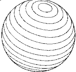
Parallels
are imaginary circles perpendicular to the axis of the Earth. They are
parallel to each other. They measure 360 degrees.
|
The Equator
is the largest parallel and it divides the earth into two hemispheres:
North and South.
|
 Parallels |
Features
- They are parallel
to each other.
- Their number is infinite.
- They have E-W direction.
- Parallels and meridians cut each other at a right angle.
- They form a circumference of 360 º.
- Their number is infinite.
- They have E-W direction.
- Parallels and meridians cut each other at a right angle.
- They form a circumference of 360 º.
Main parallels
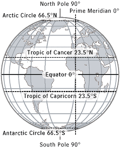 Main parallels Source: Factormonster.com |
In the northern hemisphere:
In the southern hemisphere:
|
The
meridians are imaginary maximum semicircles from the north pole to
south pole. They measure 180 degrees.
|
The
meridian of reference (0 degrees) is Greenwich. Its name comes from
the astronomical observatory located near London.
|
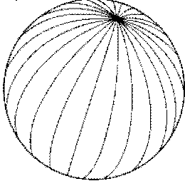 Meridians |
Features
 Meridian of Greenwich |
|
·
Vocabulary
·
-
Converge: When lines, roads, or paths converge, they move towards the same point where they join or meet
·
Exercises:
·
1. What
are the latitude and longitude lines used for?
2. Put
in a table the main features of parallels and meridians.
·
Investigator’s corner
·
-
Why the reference meridian is called Greenwich
meridian?
martes, 17 de noviembre de 2015
lunes, 9 de noviembre de 2015
SESSION 4. THE EARTH'S ORBITING AROUND THE SUN
UNIT 1. PLANET EARTH
SESSION 4. THE EARTH IN MOTION
The Earth’s orbiting around the Sun and its consequences
|
·
You have to Know…
Translation movement
|
It is the
Earth’s movement around the Sun. It describes an elliptical orbit
of 93 million km, maintaining a speed of 29.8 km / seconds.
|
A year
In this tour
the Earth spends 365 days and 6 hours. Those 6 hours which are
accumulated each year, after 4 years, they are 24 (one day). Each four years
there is one that has 366 days, called leap year.
The plane
that determines the Earth's orbit is called the ecliptic circle and is
the maximum that the Earth describes in its movement around the Sun.
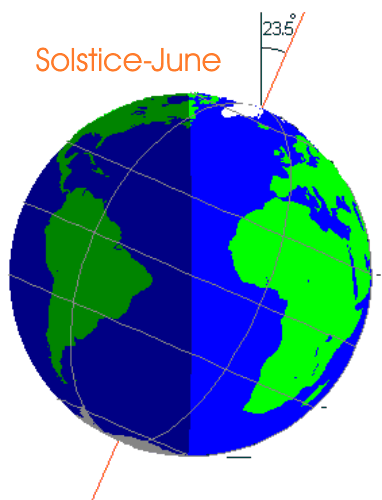
The seasons
The
translation movement causes the four seasons.
The stations
are determined by the tilt of the earth's axis on the ecliptic.
According to the position of the sun-earth connection, some areas receive more
solar radiation than others.
The change of seasons
Seasons are changing
alternately by the hemisphere which is closer to the sun. When the northern
hemisphere is the farthest from the sun, it will be winter, while
simultaneously, the southern hemisphere is closer and then it is summer there.
There are 4
key positions in the movement of translation: Spring and Autumn (equinoxes)
and Summer and Winter (solstices).
|
|
Another effect of the inclination of the axis of the Earth on the
ecliptic is the different duration of the day and the night, as Summer
or Winter.
|
|
·
Aditional
information
The
existence of thermal zones:
·
Vocabulary
-
Solstices: the time of year when there is the greatest length of daylight (summer solstice) or the shortest (winter solstice)
-
Tropical: two imaginary circles running round the earth at about 23
degrees north ( Tropic of Cancer) or south ( Tropic of Capricorn) of the equator
-
Frigid: very cold.
-
Equator: an imaginary line (or one drawn on a map etc) passing round the globe, at an equal distance from the
North and South pole
-
Season: one of the main divisions of the year according to the regular variation of the weather, length of day etc. There are four seasons:
autumn. winter, spring and summer.
-
To find out: To discover or investigate something.
·
Exercises
1. Write
down the names of the Earth’s thermal zones, and the limits that demarcate
them.
2. Are
the following statements true (T) or false (F)? Correct the false ones.
-
When one of the Earth’s hemispheres is turned away
from the Sun, it is spring or autumn. (
)
-
At the solstices, day and night are of equal length in
each hemisphere ( )
-
There are five seasons along the year ( )
-
The equator is in the frigid zone of the Earth ( )
3. Why
when it is summer in the northern hemisphere is winter in the southern?
·
Investigator’s corner
1. Find out how many Kilometers per second the
Earth travels during its revolution around the Sun, and how many kilometers it
travels a day?
Suscribirse a:
Comentarios (Atom)