UNIT 1. PLANET EARTH
SESSION 5. REPRESENTING THE EARTH’S AREA
Geographic Network
|
You have
to Know…
Geographers represent geographical space by using
maps. The Earth’s shape is almost spherical. This is why it is represented by a
globe or by projections onto a plane. Any point on the Earth’s surface can be
located with a map. We use parallels and meridians to do this.
The units
of measurement for geographic coordinates are degrees (°), minutes
('), and seconds ("). Like a circle, the Earth has 360 degrees.
Each degree is divided into 60 minutes. Each turn is divided into 60 seconds.
Latitude and
longitude coordinates also include cardinal directions: north or south
of the equator for latitude, and east or west of the prime meridian for
longitude.

·
Aditional
information
Parallels
are imaginary circles perpendicular to the axis of the Earth. They are
parallel to each other. They measure 360 degrees.
|
The Equator
is the largest parallel and it divides the earth into two hemispheres:
North and South.
|
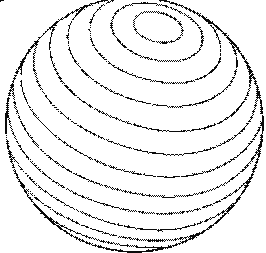 Parallels |
Features
- They are parallel
to each other.
- Their number is infinite.
- They have E-W direction.
- Parallels and meridians cut each other at a right angle.
- They form a circumference of 360 º.
- Their number is infinite.
- They have E-W direction.
- Parallels and meridians cut each other at a right angle.
- They form a circumference of 360 º.
Main parallels
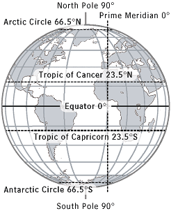 Main parallels Source: Factormonster.com |
In the northern hemisphere:
In the southern hemisphere:
|
The
meridians are imaginary maximum semicircles from the north pole to
south pole. They measure 180 degrees.
|
The
meridian of reference (0 degrees) is Greenwich. Its name comes from
the astronomical observatory located near London.
|
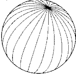 Meridians |
Features
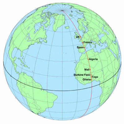 Meridian of Greenwich |
|
·
Vocabulary
·
-
Converge: When lines, roads, or paths converge, they move towards the same point where they join or meet
·
Exercises:
·
1. What
are the latitude and longitude lines used for?
2. Put
in a table the main features of parallels and meridians.
·
Investigator’s corner
·
-
Why the reference meridian is called Greenwich
meridian?
No hay comentarios:
Publicar un comentario